May 21, 2008
Patterdale to Shap
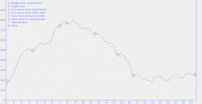
(24.7 km; 8 hrs 35 min; 1075 m ascent; 968 m descent)
Google Map
Once again our breakfast time was 7:30 am. Ian was a great host. He made us very large bowls of porridge, along with toast and tea and coffee and cereal. No fried stuff from the extensive menu, but needless to say we were very full after that. We packed up and paid our bill and were ready to be on our way by 8:45 am. Ian took out a map and showed us an alternate route which would save us the steep descent from Kidsty Pike to Haweswater.

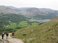
Today’s walk started just down the road from the B&B. Crossing the bridge, our route went uphill on a road for a bit before turning onto a bridleway. This path climbed steadily away from the valley and up to Boredale Hause, with very lovely views looking down the valley to Ullswater. Before long we were at Angle Tarn, which was inhabited by a small flock of Canada Geese. Here we met a group of four men of about our age or older from Carlisle, out on their twice-weekly walk in the mountains. They were very concerned that we shouldn’t get lost and made sure that we knew where to turn. They pointed out various points of interest and named the various lakes down in the valley.

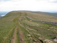
Past The Knott we headed downhill to a col, just west of Kidsty Pike. This was where Ian had told us to turn. It was difficult to see any path in that direction, but after a little bit of cross-country rambling we picked it up. It ran dead straight along a broad ridge which seemed to be an extension of High Street. Another group was going that way, including several people who we thought we recognized from the Ennerdale youth hostel and a retired school-teacher from Chilliwack named Tom.

It was cloudy today and the wind was very cold, so we put on sweaters and jackets before carrying on. We ate our lunch in the shelter of a stone wall. After about half an hour of walking, we came to the place where Ian had said we should turn right and go down a valley to a waterfall and then to the shore of Haweswater. We had the GPS with contour lines, and the other group had the Ordnance Survey map and a compass. It was evident from the contours where that valley was, but neither we nor anyone in the other group could see a path down it. So we contoured along above Haweswater, trying not to go down too steeply. The going was quite rough and there were a few steep downhills which were hard on Rosemary’s knees, but eventually we crashed down through a field of bracken right by a dam at the end of the lake.

Once down, we walked along the remainder of the reservoir before coming to Burnbanks. So now we were out of the Lake District. It was here that we went the wrong way, but luckily the others called out to us so we didn’t go too far out of the way. From here we followed the stream down the valley, through a lovely forest covered in bluebells. The sun was trying to break through the clouds, so it made quite a nice scene.

The part of the walk from here to Shap required a lot of navigation, so it was quite slow going, but it did have some pretty sections. Going through fields, following streams, and climbing stiles we made our way to Shap. En route we passed Shap Abbey, but we didn’t stop there. We just continued with the final push, which was a stretch of road into the town of Shap, where we arrived at about 5 pm.

Tonight we were staying at The Hermitage, which luckily was not at the far end of the town. The house was built in 1691 and upon entering we could see all the beautiful antiques and pictures in it. Our room was one of the four or five bedrooms upstairs and was just gorgeous. It had a sloping floor and a big ensuite bathroom down three steps.

Once we had settled in and had some tea, we went along the road to see about having dinner. There weren’t too many places to choose from, so we ended up at the one which took credit cards, the Bull’s Head pub. Paul had beef stew and Rosemary had chicken. Before we finished our meal, another C2Cer named John came by and sat with us. We had seen him up at the High Street turnoff earlier in the day. He was retired and living in Southampton. While he was eating his main meal, the two of us decided that we would share a sticky toffee pudding for dessert rather than having a whole one each. That was a good decision, since the servings were large.

After we finished our meals we headed back to The Hermitage, where we luxuriated in the large soaker tub, wrote our journals, and went to bed about 10 pm.
Elevation profile:

