May 26, 2008
Grinton YH to Richmond
(17.8 km; 5 hrs 58 min; 501 m ascent; 665 m descent)
Google Map
It had been windy overnight, and when we looked out, the sky was blue with puffy white clouds blowing by. Today we had breakfast at 8 am, but unfortunately there was no porridge available, so we made do with cereal, fruit, and toast. We went down to the drying room to pick up the shirts we had rinsed out last night, only to find that they were still damp. We tried to pack them in places where they wouldn’t dampen anything important, and once we were packed up we paid our bill and headed out, sometime after 9 am.

Neil had identified some paths on his Ordnance Survey map which went diagonally across to meet the main path, instead of plunging down the road into Reeth and starting from there. So we started down a path mostly used by mountain bikers, jumping over the stream and ducking under electric fencing, ending up in a farm yard. We followed this road east for a while, then turned left onto a public bridleway which led down to the Swale River. The C-to-C was north of the river, so we had to cross at this point, and the map showed the bridleway crossing the river.

Well, it did cross the river, and if you were riding a horse you would have had dry feet. There were some people camping in the field there who told us there was no bridge around there, but we refused to wade across and started to look around. And a short distance downstream, behind the caravan which served as the camp site’s office, we found an excellent set of stepping stones. On the other side of the river the path was quite indistinct, so we followed what appeared to be the right way and again ended up in a farmyard. This time the gate was guarded by a large barking dog, but luckily the farmer was out, so she called the dog off. She told us there were a couple of options to get to the C-to-C, and that the best route was to go back a bit and then up the Nuns’ Steps from the priory.

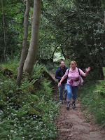
The Nuns’ Steps was a stone path going up through the woods. It was a very lovely walk through a quiet forest with wild garlic growing along the sides of the path. At the top we had great views looking across the fields. Our path from here was easy to follow, and fell into a routine of crossing field after field, with the occasional village. We stopped in Marske to have lunch in a grassy triangle in the middle of a road junction, and before leaving there we had a look around the church of St. Edmund the Martyr, which has been there since 1250.

From Marske we crossed more fields, up hill and down dale, until finally about 2 pm we came out of Whitecliff Wood and there before us was a lovely view over the Swale valley, with Richmond Castle in the middle. The track led down into the town of Richmond, and as we walked into the built-up area we could hear an announcer’s voice. In a moment we found out that the announcer was calling out a cycle race which was taking place on the grass oval of the cricket club. We watched the final laps (the lad from Glasgow won in a sprint). In the market place there was a fun fair with rides, and nearby was a beer garden with loud music. All around were clumps of teenagers, many of whom had already been to the beer garden.

We were staying at the Old Brewery, which was at the bottom of a very steep hill right by the river. We went up to our room, which turned out to have a great view looking up to the castle. Although to get to it, you had to go through a room full of hotel laundry, then up the stairs at the back. Neil and Christine weren’t staying there, but they had forgotten where they had reserved, so they left their bags with us and went out to start looking. After settling in we walked back up the steep hill to have a look at the town. It was considerably larger than previous places we had stayed in, and a lot busier due to the fair. The castle dominates the south end of the town, and north of that is the old market square, now the business district. We went into the tourist information centre and bought a dish towel identifying breeds of sheep. We also inquired about Neil and Christine, and were told they had gone to the Black Lion hotel.

Neil finally called at about 6 pm. They came down to pick up some of their things and told us about their problems. After calling almost everywhere in town, they had finally managed to get a room at the Black Lion. Christine claimed they had passed up the place which rented rooms by the hour. Then we went out to look for a place to eat dinner. That was almost as difficult, since all of the pubs were jammed full of drinkers and weren’t serving food. And we didn’t want to stand on the street eating fish and chips or pizza. But suddenly we found an Italian restaurant called La Piazza, upstairs. It had good food and luckily wasn’t full. As we left, we noticed that there were two other Coast to Coast groups there.

After dinner we parted ways with Neil and Christine. The police cars were arriving, so we headed back to our room to get ready for bed.
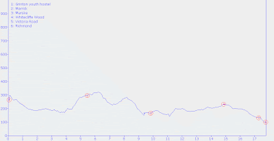
Elevation profile:

